CAPCOG, TNRIS coordinate 2021 Aerial Imagery project
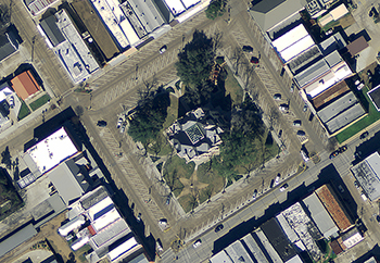
CAPCOG is seeking local jurisdictions to participate in the Texas Natural Resources Information System’s (TNRIS) Strategic Mapping Program (StratMap), so they can update their aerial imagery, or orthoimagery, for a fraction of the cost and enhance their planning capabilities. Local governments should contact CAPCOG about participating by July 17. “This is a chance to get […]
CAPCOG calls for Orthoimagery projects, geospatial savings
CAPCOG is coordinating the purchase of geospatial data through its 2020 Capital Area Orthoimagery Project in partnership with Texas Natural Resources Information System (TNRIS) Strategic Mapping Program (StratMap) as a regional cooperative effort to save local jurisdictions money. There is a May 31 deadline to submit projects. Orthoimagery is scale-corrected so governments, utilities, planners, developers […]